
About the conference
Spatial Knowledge and Information (SKI) Canada brings together the practical and the theoretical, offering a forum for researchers, practitioners, and students to share experiences in the geospatial sciences across Canada. The conference highlights best practices and cross-disciplinary approaches to spatial knowledge, inviting contributions from a wide range of fields such as geoinformatics, remote sensing, health geography, transportation, urban planning, spatial statistics, geovisualization, location-based services, GeoAI, and smart cities, among many others. Held biennially in Banff, Alberta, the program typically runs in the late afternoons / evenings, deliberately leaving mornings and early afternoons free for networking, informal collaboration, and enjoying the great outdoors. Sessions are structured around academic-style presentations with opportunities for questions and plenty of time for discussion. The conference often hosts an up-and-coming researcher as keynote speaker and a number of social events.
Now in its 9th iteration, SKI Canada has been running for 18 years, building a tradition of collaboration and advancing GIScience in Canada. Established with the "work-hard, play-hard" mentra in-mind, the conference has provided a platform for emerging and established scholars to present cutting-edge work in a supportive and engaging setting. Over nearly two decades, SKI has grown into a cornerstone of Canada's GIS research community. We look forward to continuing this tradition and will see you at SKI 2026.
Programme
Thursday, February 19
Friday, February 20
-
Do Bike Lanes Reduce Collisions? Measuring the Causal Impact of Bike Lane Implementation on Road Safety in Montreal (2005–2024)
(Jia Yu, Jean Dubé, Marie-Soleil Cloutier) -
3 Months of Discounts: Access to Shared Electric Scooters in Laval, Quebec
(Jenny Zhu, Grant McKenzie, Kevin Manaugh) -
Car Usage for Possible 15-Minute Active Transport Trips: Understanding Patterns in Saskatoon, Canada
(Esraa Othman, Ehab Diab) -
Context-Specific Approaches to Measuring School Walkability and Supporting Active Travel
(Kerstyn Lutz, Matthew Adams) -
Who Shifts to Active Modes? Understanding Seasonal Travel Changes from Winter to Fall Among Car and Transit Users at the University of Saskatchewan
(Aleena Akram, Ehab Diab) -
Quantifying Urban Mobility Responses to Snowfall Using Aggregated OD Data and Route Classification
(Haorui Zhou, Jed Long)
-
Spatiotemporal Analysis of Landscape Fire Activity and Aerosol Trends in the Context of Urbanization
(Jack Cheng, Yuhong He, Matthew Adams) -
Ephemeral Wetland Detection from Time-Series Data Cubes
(Shane Timbers, Tarmo Remmel) -
A Review of Remote Sensing and Geospatial Applications for Terrestrial Ecosystem Monitoring in Alberta's Oil Sands Region
(Ahmad Frahmand, Irini Soubry, Zhibang Lv, Xulin Guo) -
Automating Stem Location Mapping and Attribution with iPad LiDAR
(Sven Huycke, Tarmo Remmel, Shweta Parajuli) -
Comparative Analysis of SAMSTS and CCDC Gap-Filling Methods for NDVI Time Series: A 35-year Assessment
(Ahmad Frahmand, Irini Soubry, Zhibang Lv, Xulin Guo) -
Spatial Patterns of Elephant Crop Raids within an Agro-Forested Landscape
(Matthew Morrison, Dipto Sarkar, Colin Chapman)
-
Mapping Urban and Housing Change in Canada, 1990–2024: Insights from Housing and Land Cover Classification
(Iris Ka Ying Sit, David Wachsmuth) -
Geospatial Assessment of Urban Land Use
(Amelia Frazee, Mackenzie Dopf) -
Degrees of Belonging: Exploring Fuzziness in Urban Regions
(Seula Lee, Eric Heikkila) -
Evolving Patterns of Deprivation, Diversity, and Mode Share in Saskatoon’s Urban Core and Housing Accelerator Fund Areas (2006–2021)
(Olha Khrebtishcheva, Ehab Diab, Scott Bell) -
The Impact of the Housing Accelerator Fund on Population in Saskatoon
(Muqaiba Imtiaz, Scott Bell, Olha Khrebtishcheva, Ehab Diab, Marlo Edwards) -
Where Work Travels: Spatial Clustering and Distribution of Digital Nomads and Migrant Workers in World Cities
(Ebenezer Narh, Michael Buzzelli)
-
Potential of Volunteered Weather Data from Low-Cost Citizen Sensors in Micro-Scale Urban Heat Island Studies
(Priyadharshini Sakthivel) -
Shade Deserts: Mapping Shade Supply–Demand Gaps Using Hyperlocal Microclimate Simulations
(Naser Ahmed, Henry Shaver, Anastasia Soukhov, James Voogt, Jinfei Wang, Jinhyung Lee) -
Heat Stress and Diurnal Changes in Resident Presence During the 2021 Vancouver Heat Dome
(Hui Jeong Ha, Naser Ahmed, James Voogt, Jinhyung Lee, Jed Long) -
Everyday Urban Surveillance: The Semiotics of Surveillance Signage in Toronto
(Lindi Jahiu) -
The Street Divided: Dynamic Space Consumption in New York City
(Daniel Romm, Grant McKenzie) -
Urban Green Space Change in Canadian Metropolitan Areas: A Landsat–Sentinel Assessment
(Mackenzie Johnston, Grant McKenzie)
Saturday, February 21
-
2023 Wildfire Smoke Perceptions: A Spatial Mixed Methods Approach
(Amanda Norton, Amy Fernando, Jack Cheng, Matthew Adams) -
Visualization of Strava Runner Sentiment in Semi-Suburban Areas and on Trails
(Stella Harden, Nadine Schuurman) -
Participatory Mapping and Long-term Impacts
(Gaurav Thapa, Jon Corbett) -
Evaluating the Potential for Volunteer Geographic Information to Support the Humanitarian Localization Agenda
(Theresa Dearden, Jon Corbett) -
Mapping with, not just for, Nature: Exploring the Implications of More-than-Human Participatory Mapping for Environmental Stewardship
(Ayla De Grandpre, Jon Corbett) -
GIS for Labour Justice: The Del Monte Oshawa Case
(Christopher Sorio)
-
Spatial Fairness in LLMs for Digital Agriculture: Trends, Limitations, and Research Gaps
(Yasaman Honarparvar, Ronnie De Souza Santos, Steve Liang, Sara Saeedi) -
Natural Language to DGGS-Aware Methane Insights with a Multi-LLM-Agent Framework
(Mingke Li, Steve Liang) -
From Real to Synthetic: Using CTGAN to Model Socio-Spatial Populations for AI and Policy
(Navid Mahdizadeh Gharakhanlou, Liliana Perez, Yan Kestens, Benoit Thierry) -
LLM-Driven Agent-Based Modeling Framework for Cost-Effective LDAR Program Design
(Jinya Wang, Steve Liang) -
Interactive GIS Reasoning: An Agentic Framework for Natural Language Spatial Queries
(Vivek Suresh Raj) -
A Multi-Modal GeoAI Framework for Climate-Linked Urban Crime Prediction in Canadian Prairies
(Naiyandikarige Chamathka Jayashankanie Thilakarathna, Varuni Jayasooriya)
-
Mapping Mobility Barriers: A Comparative Evaluation of Five Accessibility Platforms
(Harrison Drew, Victoria Fast) -
Mapping the Urban Mobility Divide: Spatial Patterns of Transportation Poverty in Saskatoon
(Anu Yadav, Jacob Alhassan) -
Examining the Usability of a Geospatial Data Visualization Tool to Better Understand Transportation Choices
(Leandro Meneguelli Biondo, Stuart McGorman, Nicholas Blackwell, Jon Corbett) -
Pedestrian Level-of-Service (PLOS) and Walkability Equity in Saskatoon: A Gender-Based and Health Analysis
(Patricia Salazar-Ramirez, Meisam Ghasedi, Daniel Fuller) -
Engaging Disability in GIScience Curriculums
(Lisa Rotzal, Victoria Fast) -
Beyond Proximity: Socioeconomic and Health Contexts of Prenatal Care Travel Patterns
(Anastasia Soukhov, Ava Hudson, Justin Yu, Yuhao Kang, Hanqi Li, Peiyin Hung, Armita Kar)
Call for Papers
The 9th conference on Spatial Knowledge and Information (SKI) Canada will take place February 19-22, 2026, in Banff, Alberta. Since 2008, SKI has been the pre-eminent Canada-centric conference for geographic information science (and systems), spatial data science, remote sensing, geomatics and the geoweb research. The conference is aimed at researchers at all stages, from undergraduates to retired faculty and all types of educational institutions, from community colleges to universities and research institutes. SKI has been important to researchers, allowing them to share their research ideas and identify potential graduate students. This has been a great place to highlight your research and perhaps ski as well.
This year, as in previous years, we are inviting submissions on a range of topics such as papers and abstracts for peer-review and publication. Early career researchers and graduate students in particular are encouraged to apply.
The conference mixes practical and theoretical aspects of geographic information science. Come share your experiences in using GIS in academia in Canada and around the world. Learn from others on best practices and ways of accommodating different domains of knowledge.
We invite submissions on a range of topics including (but not limited to):
- GIScience
- Remote sensing
- Spatial Data Science
- Geomatics and Geomatics Engineering
- GeoAI, spatial big data, and machine learning
- Participatory GIS
- Spatial qualitative and mixed methods
- GIS in health and epidemiology
- GIS in transportation
- GIS in hydrology
- Geoprivacy
- Planning Support Systems and land-use planning
- Digital Earth and the Geospatial Web 2.0 (geoweb) (e.g., Google Earth, Virtual Earth, Google Maps) Research
- Neogeography, Volunteered Geographic Information (VGI) and crowdsourcing
- Geovisualization and cybercartography
- Spatial Business applications
- Spatial statistics
- Location based services
- GIS and spatial modeling in Earth Sciences
- Urban simulation and modelling
- Computer dimensions of GIS (e.g., data modelling)
- Big Data, machine learning, Geo AI
- Smart Cities & Artificial Intelligence


Who should attend?
Students of all levels (undergraduate, masters, and PhD) and researchers who identify as GIScientists, Spatial Data Scientists, Remote Sensors, Geomatics Researchers or GIS Applications users from across Canada. We invite participants from academia, industry, and government. We are particularly interested in students attending the conference so please share this call for papers within your departments.
How to participate
There are three main avenues for researchers to contribute to the SKI 2026 conference: i) full paper submissions, ii) abstract submissions for early-stage students, and iii) faculty research synopses.
Paper Submissions
Papers can be up to 2000 words in length and a maximum of 10 pages (including figures and references). Each paper will be reviewed by the Program Committee and feedback will be provided to the authors. Accepted papers will be published in the SKI conference proceedings via Zenodo. In addition to gaining experience with the review process, students should be aware that each paper is given a persistent identifier (DOI) and indexed, which may be useful for their CV.
Download the paper template here
Submissions are closed
Abstract Submissions
For students who have been registered in their programs for less than six months (as of the deadline of abstract submission), we invite submission of a short abstract (200–300 words). Short abstracts will not be included in proceedings but are an opportunity to discuss and receive feedback from your peers. Short abstracts should include the research context, goal, methods, anticipated results, and expected impacts. Short abstract submissions must be accompanied by an email or letter from the student’s supervisor indicating they have reviewed and approved the submission and confirmation that the student has been in their program of study for less than six months. If new students have sufficient results, a comprehensive literature review or a well-developed methodology, we encourage them to submit to the paper stream.
Download the abstract template here
Submissions are closed
Research Synopsis
Faculty are alternatively invited to participate by providing a short research synopsis and a written summary of their research program. During the conference, each faculty will give a 2-minute elevator pitch highlighting the general scope of their research and submit a 300-word summary that will be posted on the conference website (note: summaries will not be part of the peer-reviewed proceedings).
Submit synopsis here
Schedule
The full conference event will be held from Thursday, February 19 to Sunday, February 22, 2026. The conference begins with an icebreaker and social on Thursday night, with paper presentations commencing Friday, February 20 and continuing Saturday, February 21. Further details will be posted following the submission deadline.
Structure
The conference will be structured as a series of plenary sessions: each hosted by a moderator. Conference sessions will be designed around a rapid-communication format successfully used in medicine, neuroscience, and other disciplines. Each presentation will be 5-10 minutes (depending on paper format) with a short, shared opportunity for public questions. Additionally, each evening of the conference will include a dinner reception offering ample time for interaction and discussion. The two dinner receptions will also include a keynote address (Friday) and a Conference photo “competition.”
Important Dates
Submission deadline: November 21 November 29 (End of day AOE)
Paper notifications: December 19
Resubmission of papers on Easychair (after addressing comments): January 16 January 30
Conference dates: February 19-22
Sponsor
We would like to thank the following sponsor for their support of the Canadian Spatial Knowledge and Information Conference.
Keynote
Community Co-Developed Satellite Systems
While climate change is affecting every community on Earth, northern communities are experiencing its effects at a rate four times faster than everywhere else. As these communities rely on the land, air, and water for food, travel, and wellness, the threats from climate change and geopolitical tensions across the Arctic jeopardize their security. Satellite technology promises solutions to many challenges with potential to deliver remote sensing, situational awareness, and high-bandwidth communications, but making these solutions accessible to isolated northern communities remains elusive. The Space Technology and Advanced Research Laboratory (STARLab) at the University of Manitoba has been working with Inuit communities in the Arctic (e.g., Chesterfield Inlet, Nunavut), to co-develop space systems that will provide enhanced communications and security for community members out on the land and on the sea-ice. The co-development nature of our research provides a platform for respectful bi-directional knowledge transfer, blending Indigenous Knowledge with Western science to improve community safety and security. The communities own, operate, and maintain their space systems with support as required from the University of Manitoba. By working and learning together, we are able to foster enhanced community in the face of accelerated climate change and security tensions for Canada’s north.
Philip Ferguson is a space systems engineer and Professor of Aerospace Engineering at the University of Manitoba. He is the Director of the Space Technology and Advanced Research Lab (STARLab) in the Price Faculty of Engineering at the University of Manitoba where his research focuses on making aerospace technology accessible to northern communities in Canada to make them more resilient and secure.
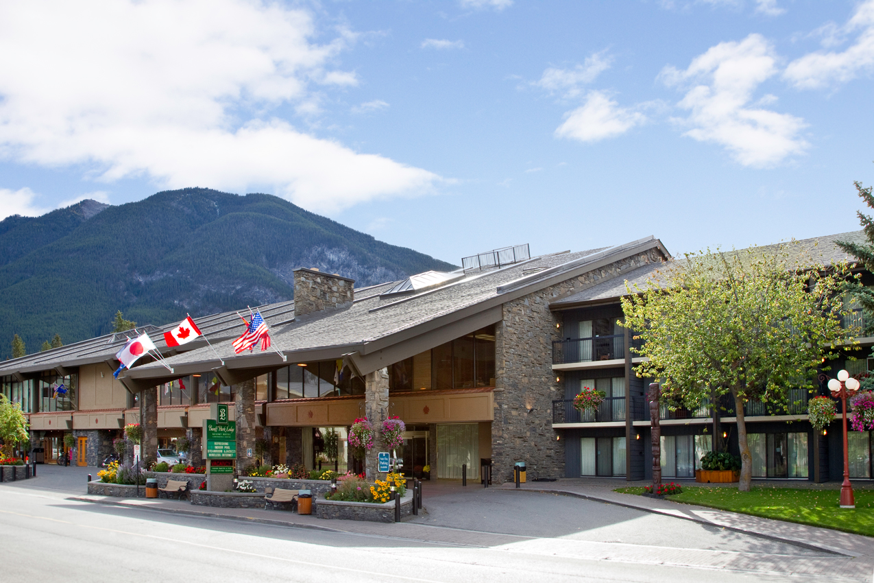
Venue
This year's conference on Spatial Knowledge and Information Canada will be held at the Banff Park Lodge.

Accommodation
We have reserved blocks of rooms at the hotels listed below. Reserve your rooms early!
- Banff Park Lodge - The same building as the conference
- Bow View Lodge - Next door to the conference venue
- Peaks Hotel & Suites - Across the street from the conference venue
Travel
The Banff Park Lodge is located in Banff, Alberta and is roughly 1.5 hours from the Calgary International Airport. From the airport, the best option for getting to Banff is via shuttle. There are a few options including:
- The Banff Airporter - Use code SKIC2026 for a 15% discount.
- Brewster Express
Check out the top things to do in (and around) Banff before or after the conference.
Social Events
On Thursday evening (February 19) at 7:00pm, we will kick off the conference with a Meet & Greet upstairs at Banff Ave Brewing Company. This is a great opportunity to meet other participants in a casual environment and set the tone for the days to come.
Registration
Registration comes with two catered banquet dinners and coffee and refreshments throughout the conference.
Early bird (Register by January 9)
Register as a Student
$250
Register as a Postdoc
$350
Register as Faculty or Other
$550
Regular (Register by January 29)
Register as a Student
$300
Register as a Postdoc
$400
Register as Faculty or Other
$600
Faculty Synopses
Matthew Adams is an Associate Professor in the Department of Geography, Geomatics and Environment at the University of Toronto Mississauga, and Director of the Centre for Urban Environments. His research examines how urban form, infrastructure and policy shape exposure to environmental exposures and related health and equity outcomes in Canadian and global cities.
Dr. Adams’ work integrates atmospheric science, spatial data science and public health to understand fine-scale variation in pollutants such as ultrafine particles, PAHs, NO₂ and other traffic- and industry-related contaminants. He develops and applies innovative monitoring approaches, including passive samplers, mobile measurement campaigns, and open-source data pipelines, to generate high-resolution exposure surfaces that are directly usable by partners in public health, planning, and regulation.
A core theme of his research is environmental justice. Dr. Adams collaborates closely with municipalities, public health units and community organizations to document how pollution burdens and environmental amenities are unevenly distributed across neighbourhoods by income, immigration status and other social determinants of health.
Through community-engaged and participatory projects, his group co-designs tools such as GIS dashboards, story maps and citizen science monitoring campaigns that make complex environmental data accessible and actionable for residents and decision-makers.
Dr. Adams has led and contributed to interdisciplinary projects on topics including industrial emissions, freight corridors, and healthy city planning. His research aims to provide robust, policy-relevant evidence to inform standards, mitigation strategies, and long-term urban planning to reduce exposure, advance health equity, and support more sustainable, liveable cities. Adams is also deeply involved in mentoring highly qualified personnel, training students in GIS, R-based spatial analysis and community-engaged methods. His teaching and supervision emphasize open data, reproducible workflows and knowledge translation, ensuring that research findings move beyond academic publication to support residents, advocacy groups and policy-makers working toward cleaner air and healthier urban environments.
I am Dr Jacob Alhassan, an assistant professor in community health and epidemiology at the college of medicine of the university of Saskatchewan. My research program is anchored around three interconnected streams: 1. community engaged research on power, politics and health, 2. research on transportation and the wellbeing of vulnerable communities and 3. global health research.
Funded through grants from the Saskatchewan Health Research Foundation (SHRF), the Canadian Institutes for Health Research (CIHR) and the Social Sciences and Humanities Research Council of Canada (SSHRC), my research on transportation and the wellbeing of vulnerable communities explores how government political decisions such as austerity policies (budget cuts to public transportation) influence the wellbeing of rural and remote communities in Saskatchewan.
This work has focused on documenting impacts of lack of transportation on physical and mental health of Saskatchewan residents and the health system. It has documented health system wastages due to lack of transportation as well as the psychological toll of disconnection associated with lack of transportation. It has also sought to measure personalized financial costs due to transportation barriers.
Additionally, this research has taken on a strengths-based approach exploring community responses to budget cuts to transportation. This aspect of my work and has focused on identifying and documenting free transportation initiatives and their health impacts drawing on case studies from Saskatchewan and Alberta.
Through scoping reviews, mixed methods studies and more recently geographical information systems (GIS) based analysis, my research seeks to document the health impacts of lack of transportation while centering homegrown community initiatives that seek to respond to transportation barriers.
In 2016, with Kevin Stanley, a computer scientist now at UVic, we were fortunate to have the opportunity to conduct two opportunistic studies. One examined the impact of Pokemon GO; the second coincided with a transit strike that occurred in the middle of Fall term, disrupting many University commutes.
The Pokemon GO study showed how gamification could activate underused public spaces, while the transit strike revealed students' spatial constraints and adaptive commuting strategies.
Much of my work (past and present) has examined the impact of an outside force on an element of human action (navigation, movement, housing, and social deprivation).
Currently, with students, colleagues, and collaborators, I am examining how the federal government's intervention into local planning will impact Canada's urban landscape. This research is funded by SSHRC, Research Junction (research partnership between USask and City of Saskatoon), and Mitacs.
Muqaiba and Olha presented (will present?) preliminary findings from this work earlier in the conference. In particular, we are analyzing how HAF requirements, particularly zoning reforms and density mandates, will reshape Canadian cities' spatial form and housing accessibility.
In my role as an educator, I weave this research into my teaching at the undergraduate and graduate levels. At the University of Saskatchewan I teach Geomatics, cartography, and human geography. This spatial lens connects local lived experiences with broader patterns of urban change and policy impact.
Dr. Ehab Diab is a transportation researcher and educator whose work focuses on improving the sustainability, accessibility, and user experience of public transit and active transportation systems.
His research integrates quantitative methods, travel behaviour analysis, and spatial analytics to better understand how people move through cities and how transportation networks can be designed to support healthier, more equitable, and more efficient communities.
Dr. Diab's work spans several interconnected areas, including transit planning and operations, transit user experience, multimodal accessibility, cycling and walking behaviour, and the evaluation of policy interventions such as the 15 minute city.
He collaborates extensively with international partners and transportation agencies, contributing practical knowledge that informs real-world planning and investment decisions.
In addition to his research, Dr. Diab plays an active role in the academic and professional transportation community, including positions within the US Transportation Research Board (TRB) and engagement in global conferences and interdisciplinary initiatives.
Heading the geospatial data science support unit at McGill university. Our services range from knowledge transfer on GIS and remote sensing software, programming and methodological skills to individual project support.
We offer aerial imagery taking services through our drones to high-performance computing and precision-GNSS devices.
Our team is currently working to support projects on historic GIS in Montreal, curating transport-related datasets and geospatially enhancing psychological sleep studies.
My research program sits at the intersection of GIScience, urban studies, and disability justice. I lead the Accessible Mapping Research Lab at the University of Calgary, where we develop disability-inclusive spatial data, indicators, curriculum, and decision-support tools that help cities identify and reduce the barriers that exclude people with disabilities from everyday life.
A core goal is to make accessibility measurable at city scale without losing the nuance of lived experience. We combine community-engaged methods (participatory mapping, citizen science, and volunteered geographic information) with computational approaches (spatial modelling, geovisualization, and GeoAI) to map barriers across sidewalks, streets, public spaces, and buildings.
Recent work includes Mapping Our Cities for All (MOCA), a national initiative that mobilizes mappers to audit building accessibility across Canada, and WalkRollMap barrier inventories that document sidewalk and street obstacles affecting mobility, sensory, and cognitive access.
Methodologically, our team integrates diverse data sources such as field audits, OpenStreetMap, municipal datasets, street-level imagery, and LiDAR into reproducible workflows that support data quality assessment, uncertainty communication, and open reuse.
We prototype accessibility metrics including barrier density and severity indices, accessible-route network models, and intervention prioritization tools, and we test how different cartographic designs affect interpretability for users with varied visual, cognitive, and situational needs.
Conceptually, we draw on disability studies and critical data perspectives to ask what gets counted as accessible, who defines it, and how metrics and standards travel into policy and practice. This includes attention to governance, openness, and data standards that enable interoperability across platforms and jurisdictions.
Across projects, we partner with disability communities, nonprofits, and municipalities to co-create actionable targets, evaluate interventions, and translate findings into open data products and accessible visualizations. At SKI Canada, I will share lessons on building disability-inclusive spatial knowledge infrastructures that are rigorous, transparent, and designed to work for everyone.
I am an Associate Professor in Community Health and Epidemiology at the University of Saskatchewan and have an appointment in the Department of Computer Science at USask. My research focuses on how urban environments and transportation systems influence physical activity, equity, and health outcomes.
I lead three large national projects. On called INTERACT, which is a cohort study using GPS and accelerometer sensors to understand the impact of changes to the built environment on physical activity. We have lots of data and do considerable work developing new methods to understand human mobility using these data.
The second project is CapaCITY/É, which is an interdisciplinary team of university researchers, city partners, and national organizations looking to catalyze the implementation of sustainable transportation interventions to support health, mobility, and equity outcomes in jurisdictions across Canada and Australia.
Finally, I also work one developing nationally standardized indicators of urban environment features including walkability and sprawl. These indicators are used in large scale longitudinal studies examining the health impacts of urban form changes.
My research lab the Built Environment and Active Populations (BEAP) lab is a unique training ground for students in epidemiology, public health, geography, urban planning, and computer science. My previous students currently hold positions as medical doctors, research analysts for national and provincial public health agencies, start up founders, and working for large international tech companies (Meta and Huawei). As part of the BEAP lab, students receive both broad training in public health and epidemiology, along with specific opportunities that suite their expertise and interest.
By 2050, close to 70% of the world’s population will be living in cities. That simple fact drives my work. If cities do not function well environmentally or socially, then sustainability does not work at all.
I am an environmental engineer in training and an Assistant Professor at the School of Environment and Sustainability (SENS) at the University of Saskatchewan (USask). My research focuses on how cities can be designed to remain livable as they grow, by reducing heat, strengthening climate resilience, improving health, and ensuring fair access to green spaces.
Long before I knew what urban sustainability meant, I was drawn to large metropolitan cities. As a child, I was fascinated by how roads, buildings, parks, and people came together to form complex systems. At the same time, I loved maps. I spent hours looking at atlases and city layouts, trying to understand how everything fit together. That curiosity eventually became my research career.
Today, maps, satellite imagery, and remote sensing shape how I think. Spatial data allows us to see cities as systems, revealing heat hotspots, uneven tree cover, and gaps in access to parks that are hard to detect from the ground. I lead the Geospatial Intelligence for Green Cities (GIG-Cities) Lab at USask, where our work integrates multidisciplinary domains such as environmental sciences & engineering, geospatial data science, sustainable urban planning, and environmental and social geography.
We use GIS, remote sensing, geospatial AI, and spatial analytics to study urban heat islands, microclimates, urban forestry, parks, and green infrastructure. We also work on age-friendly cities, equitable access to everyday nature, and urban safety using spatial analysis and computer vision.
Across all of this, the goal is simple: to use interdisciplinary tools and spatial data to help cities become cooler, healthier, fairer, and better prepared for the future.
The fusion of Internet of Things (IoT), AI agents, and digital twins is ushering in a new paradigm for understanding, simulating, and governing complex real-world systems. This presentation builds on the concept of the digital twin as an “AI gym” — a living, executable representation of physical reality where intelligent agents can continuously learn, test strategies, and safely interact with the world before acting within it.
We argue that the next generation of AI systems will not be driven by larger models alone, but by richer, semantically grounded digital environments. Raw IoT data streams are inherently heterogeneous, noisy, and poorly structured for autonomous reasoning.
By embedding sensor observations within standardized observation models, domain ontologies, and explicit physical and causal constraints, digital twins evolve from passive mirrors into operational intelligence platforms. They provide the contextual foundation required for AI agents to reason across space, time, and system behavior with transparency.
Through real-world deployments in environmental monitoring and industrial operations, we demonstrate how this approach unlocks scalable interoperability, improves auditability of AI decisions, and accelerates responsible autonomy.
Ultimately, we position digital twins as the critical operational layer between sensing and intelligence — the structured reality in which AI agents are trained, validated, and trusted to manage the increasingly complex cyber-physical systems shaping our world.
My research program examines how digital technologies physically ‘show up’ on city streets, and also how cities of various sizes serve as sites of digital innovation and experimentation (with a focus on mid-sized Canadian cities).
A current project on digital urban aesthetics that I am working on with Dr. Jon Cinnamon and our graduate students investigates how digitally-mediated platform presences from micromobility vehicles to insulated on-demand delivery cubes are changing what cities look like, and what kinds of urban narratives are secured by these presences in rapidly changing cityscapes.
As part of this research, we are developing methods for collecting geotagged 360-degree imagery (still and video) as novel techniques for capturing and analyzing the urban scene.
In the future, I will shift my focus from digital platforms to how AI from infrastructures to autonomous objects is showing up at street level, and how these materialities of AI are visually transforming cities as urban environments are reconfigured to facilitate and accommodate these new materialities.
Simultaneously, I am engaged in ongoing work to theorize the nature of urbanism through the lends of ‘digital glitches’ – that is, city spaces and times where digital technologies and mediations show up unexpectedly, differently than anticipated, or not at all. I am interested in how this changes how we understand processes and effects of the coming together of digitality and cities.
Grant McKenzie’s research explores the relationship between people, place, and movement through the lens of spatial data science, with a particular focus on human mobility, geoprivacy, and the growing influence of digital trace data on understanding urban systems. Grounded in Geographic Information Science, his work develops empirical, computational, and theoretical approaches to characterize how individuals and communities interact with urban environments, and how these interactions reflect broader issues of accessibility and sustainability.
A central theme of Prof. McKenzie’s scholarship is platial data science, an extension of spatial analytics that integrates semantic, temporal, social, and behavioural signatures to model how people use and conceptualize place. He has advanced this area through contributions on semantic signatures, points of interest, uncertainty visualization, geosocial data, and place-based similarity.
In addition to this line of research, Prof. McKenzie studies micromobility and active transportation using large-scale datasets from shared e-scooter, e-bike, running, and other human-scale mobility platforms. These analyses demonstrate how emerging mobility services reshape access, infrastructure allocation, and patterns of mobility equity across regions.
Another facet of Grant’s research concerns geoprivacy. This involves the development of methods, tools, and conceptual frameworks for protecting individuals in an era of pervasive location data. Through projects such as PrivyTo and work on temporal popularity-based k-anonymity, Prof. McKenzie examines privacy-preserving analytics and ethical considerations in geospatial AI.
Research from Grant McKenzie’s group integrates GIScience, urban analytics, machine learning, human-computer interaction, and social science perspectives. His work contributes to broader debates on mobility justice, sustainable cities, and responsible AI. Through the Platial Analysis Lab at McGill University, he collaborates with a range of partners to produce policy-relevant insights and open, reproducible tools for understanding cities and the people who move through them.
The Spatial Agents and Urban Analytics Group at the Department of Geography, McGill University, focusses on a combination of agent-based modelling (ABM) and sensor-based analysis to understand Urban-focused, and often climate-related, topics. These include ABMs of customer shopping behaviour, and an understanding and simulation of the Urban Heat Island (UHI) phenomenon.
Specifically, increasing urbanization (that is, densification by redevelopment of buildings in the urban core) and climate change both tend to exacerbate UHI over time. It therefore becomes imperative to use simulation tools and develop a complex-systems understanding of the impact of UHI over time.
Towards this goal, my lab is developing both a sensor-based understanding of temperature hot-spots within a city, as well as trying to understand its impact on human health and populations over time.
For example, it has been noted that at the city level, the intensity of intra-city CUHI (i.e., the differences in UHI intensity within a city) is heterogeneous. This is primarily because of variability in the urban fabric, including the presence of green infrastructure (e.g., urban parks, green alleys) that locally reduce UHI.
For example, UHI intensity has been previously related to the percentage of vegetation and Sky View Factor (i.e., the percentage of open sky visible from a location and represented as a fraction) within 500 m of urban weather station.
Additionally, we are using advanced simulation tools (particularly Agent-Based Models) to simulate the growth and densification of Canadian cities and its impact of intra-city UHI, as well as simulate the ability of individuals with limited mobility and differing socio-economic status to access mitigation measures like cooling centers.
Dr. Jue Wang’s research program investigates how GeoAI—the integration of geographic information science, spatial analytics, and artificial intelligence—can advance our understanding of urban environments, public health, and human well-being. As Director of the GISpark Lab at the University of Toronto Mississauga, Dr. Wang leads a dynamic, interdisciplinary team that develops novel data-driven methods to analyze the spatial and temporal relationships between environmental exposures, human behavior, and health outcomes.
His research leverages large-scale geospatial data sources—such as street-level observations, portable environmental sensors, and mobility traces—combined with advanced machine learning and time-geographic modeling techniques. These approaches are used to quantify the health implications of urban features like noise, light pollution, greenspace accessibility, and food environments. By integrating physical, digital, and social dimensions of cities, Dr. Wang’s work reveals how everyday urban experiences shape health disparities and contribute to broader questions of livability and equity.
Current projects focus on how inflation, digital transformation, and climate stress jointly influence food access, consumption behaviors, and public well-being. Working closely with academic and policy partners across Canada, the United Kingdom, and the United States, his team bridges scientific modeling with community engagement and evidence-based policymaking.
The overarching goal of this research program is to promote ethical, inclusive, and human-centered GeoAI that strengthens both scientific understanding and practical action. By connecting technological innovation with public health and urban planning, Dr. Wang’s work contributes to designing more resilient, equitable, and health-promoting living environments—where data and algorithms serve not only as analytical tools but as catalysts for social good and sustainable futures.
David Wachsmuth is the Canada Research Chair in Urban Governance at McGill University, where he is also an Associate Professor in the School of Urban Planning. He directs UPGo, the Urban Politics and Governance research group at McGill, where he leads a team of researchers investigating pressing urban governance problems related to economic development, environmental sustainability, and housing markets.
His team develops new methods (often computational and/or geospatial) to tackle research questions which we know are important but are still understudied because of data limitations. These include the structure of rental housing ownership, the impact of short-term rentals on cities, and the role of evictions in housing markets.
David is also the president and co-founder of Curbcut, an award-winning startup connecting communities with data through cutting edge geospatial analysis and visualization. Through Curbcut he leads a project with the federal government to develop a predictive model of housing supply and affordability across 11 Canadian regions.
Alexander 'AJ' Wray is a health geographer that examines the how the design and planning of communities affects youth populations. He is appointed as an Assistant Professor of Community Health Education at the University of Tennessee Knoxville Department of Nutrition and Public Health Sciences. He is also appointed as an Adjunct Research Professor at The University of Western Ontario Department of Geography and Environment.
The primary focus of his research is further developing and applying geographic ecological momentary assessment and digital methodologies to community health challenges. A secondary focus of his research is on the role of temporality as it relates to health and behavioral outcomes in the traditions of more-than-representational theory and ecological systems theory.
Presently, Dr. Wray is supporting the development of a physical activity-based park prescription intervention trial for (pre-)diabetic patients in London, Mississauga, Montreal, and Toronto. He is also involved in studies of youth experiences of public space in high-rise cities, the daily travel patterns of caregivers, and the creation of a Student Housing Observatory for Ontario and Quebec.
He is Member of the International Science Council's Global Roster of Experts, a Candidate Registered Professional Planner in Ontario, a Board Member of the International Town and Gown Association, and the Past President of the Town and Gown Association of Ontario.
The yet-to-be-named Wray Lab will provide a transdisciplinary training environment for the development of behavioural and societal interventions that can support young people in leading healthy and thriving lives in vibrant places in Canada and the United States of America. The goal of his lab is to prepare doctoral students to pursue a wide range of academic, governmental, and industry careers with personalized development plans. He is interested in supervising PhD students with interests in health geography, computational GIScience, urban planning, or behavioural medicine.
Organizing Committee
General Chairs
Scott Bell, University of Saskatchewan
Renée Sieber, McGill University
Nadine Schuurman, Simon Fraser University
Grant McKenzie, McGill University
Program Chairs
Ehab Diab, University of Saskatchewan
Jed Long, Western University
Liliana Perez, Université de Montréal
Local Arrangements
Victoria Fast, University of Calgary
Steve Liang, University of Calgary
Stella Harden, Simon Fraser University
Program Committee
Luke Bergmann, The University of British Columbia
Jonathan Cinnamon, The University of British Columbia
Jon Corbett, The University of British Columbia
Tim Elrick, McGill University
Daniel Fuller, University of Saskatchewan
Jason Goetz, Wilfrid Laurier University
Xulin Guo, University of Saskatchewan
Varuni Jayasooriya, University of Saskatchewan
Peter Johnson, University of Waterloo
Brian Klinkenberg, University of British Columbia
Jinhyung Lee, Western University
Agnieszka Leszczynski, Western University
Karim Malik, University of Windsor
Kevin Manaugh, McGill University
Tarmo Remmel, York University
Claus Rinner, Toronto Metropolitan University
Dipto Sarkar, Carleton University
Raja Sengupta, McGill University
Michael Sawada, University of Ottawa
David Wachsmuth, McGill University
Jue Wang, University of Toronto Mississauga
Michael Widener, University of Toronto